Tuesday, July 28, 2026
News and Views from the Global South

COLOMBIA: Amazonas 2030 – Indicators for the Climate Crisis
Constanza Vieira * - Tierramérica
- “It’s great news” that the Colombian government is studying the cancellation of mining titles that have been granted in protected areas and in border zones declared national security areas, anthropologist Martín von Hildebrand, director of the Gaia Amazonas Foundation, told Tierrramérica.

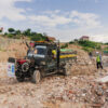
Port of the Amazon indigenous community of San Miguel on the Pirá Paraná River, in the department of Vaupés, Colombia. Credit: María Cristina Vargas/IPS
In the Amazon region as a whole there are currently valid mining titles for 138,571 hectares of land. Requests are being processed for titles that would cover a further 5.4 million hectares, according to the Ministry of Mines and Energy.
“Unfortunately,” warned Von Hildebrand, “we also have to keep in mind that while certain areas are being defended, such as national parks and national security areas, the people who are there now looking for minerals will move to other areas without this kind of protection.”
This is why there is a need for strict policies for monitoring and control of other parts of the rainforest, he added.
Sixty percent of the Colombian Amazon is forested area with a certain degree of protection. Mining titles can be granted in these areas, but require an environmental license.
The Ministry of Mines and Energy’s announcement that it is studying the cancellation of mining concessions was made on Oct. 26 at the presentation of the Amazonas 2030 Index, developed by an alliance of the same name which collects social, environmental and economic data on the Colombian portion of this rainforest that constitutes the heart of South America.
The study is innovative in that it grants the same importance to the dimensions of the environment and indigenous communities as it does to economic, social and institutional dimensions. Each has a weight of 20 percent. The lowest possible value for the index is zero (the worst scenario) and the highest is 100 (the best).
The result is a balanced strategic analysis: just the vision required in the face of the environmental crisis and climate change, in contrast to typical studies that emphasise economic considerations.
The key lies in measuring the quality of life of ecosystems. If this were measured in the Amazon according to the index of unsatisfied basic needs, the result would be that Amazon indigenous communities live in extreme poverty, and this is not the case.
By taking into account the environmental component and indigenous communities’ ancestral knowledge of and ties with their territories, it can be objectively verified that the rainforest and culture provide quality of life.
Meanwhile, through dozens of variables that could be classified as “conventional” – such as educational level and public services – the index measures the effects of public policies, in the first place, and private management, secondly.
“The idea is that, for better or worse, this is what the state is dealing with in the Amazon. And then, it is a matter of making it understood that these indicators for the Amazon are developed on other bases,” biologist Natalia Hernández, who coordinated the initial design of the Amazonas 2030 study, told Tierramérica.
“Simply taking into account the cultural, social and environmental dimensions to the same degree as economic and institutional dimensions paves the way for a vision of development from the perspective of the Amazon,” she added.
Amazonas 2030 is an alliance of non-governmental organisations, the private sector and the media aimed at promoting sustainability and quality of life in the Colombian Amazon and positioning the region on national and global agendas.
Its name refers to the fact that, according to the Intergovernmental Panel on Climate change, if the current rate of deforestation continues, by 2030 more than half of the Amazon rainforest will be severely damaged.
Official figures on the Colombian Amazon region are so lacking that the researchers specified that “it was difficult to obtain a large part of the data, especially figures on timber transport permits, ethnic education and the legalisation of extractive activities in forest reserves, among others.”
Moreover, the statistics gathered and included in the index correspond only to urban settlements. “The index does not reflect the cosmovision of indigenous peoples, due to the lack of data that could capture it,” the methodological notes indicate.
Perhaps the variables for which the lack of data is most significant are those related to health, which do not take into account the work of shamans, whose impact has never been measured.
The departments assessed are Amazonas, Putumayo, Caquetá, Guaviare, Vaupés and Guainía, which together cover 403,348 square km in south and southeast Colombia.
The Sinchi Amazonic Institute of Scientific Research includes nine municipalities in the department of Meta, one in Vichada, three in Cauca and four in Nariño in its definition of the Colombian Amazon region, leading to a total of 483,164 square km, or 42 percent of Colombia’s entire continental area of 1.1 million square km.
Colombia is home to 17 percent of the rivers in the entire Amazon region, which in turn is the source of 20 percent of the planet’s fresh water. Because of its huge size, the Amazon also contributes significantly to regulating the global climate.
But the geographic size of the Amazon varies, depending on three different ways of defining this area of extraordinary biological and cultural diversity.
One views the Amazon as a region or biome, and includes the Amazon River basin and parts of the basins of the Orinoco and Paraná Rivers. Another encompasses the basin of the Amazon River and its tributaries. And finally there is the political-administrative Amazon region in each individual country, used in terms of planning and development.
Bolivia, Peru and Ecuador, like Colombia, are referred to as “Andean” countries. In reality, however, almost half of their territories falls within the Amazon rainforest region.
Venezuela defines its Amazon region as including only the Amazon River basin, on the southern edge of the southern state of Amazonas. The rainforests in the rest of the state of Amazonas and much of the state of Bolívar, south of the Orinoco River, are officially defined as the Venezuelan Guayana.
The overall result of the Amazonas 2030 Index is 51.4, although it is an average formed out of marked contrasts.
In the department of Caquetá, close to one half of the rainforest has been destroyed, in Putumayo, one quarter, and in Guaviare, one third. These three departments of the northwest Amazon region are characterised by a high proportion of European settlers, very few indigenous communities and reserves (territories under indigenous administration), numerous large cities and highly developed road infrastructure.
On the other hand, the departments of Amazonas, Vaupés and Guainía have very little deforestation, greater ethnic diversity, smaller urban centres, large reserves and national parks, and no road infrastructure.
The differences between these two sub-regions of the Colombian Amazon are clearly reflected in a perception survey conducted among the region’s inhabitants, also released by Amazonas 2030 but only covering urban centres so far.
*The writer is an IPS correspondent. This story was originally published by Latin American newspapers that are part of the Tierramérica network. Tierramérica is a specialised news service produced by IPS with the backing of the United Nations Development Programme, United Nations Environment Programme and the World Bank.
 Print
|
Print
|


Pictures for this story
This story includes downloadable print-quality images -- Copyright IPS, to be used exclusively with this story.